


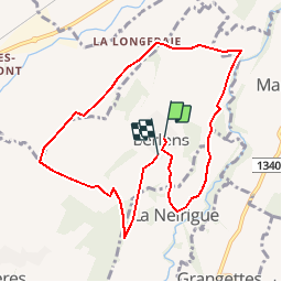


8,5 km | 10,6 km-effort


Benutzer


Kostenlosegpshiking-Anwendung
 SityTrail
IGN / Geografische Institute
SityTrail World
Die Welt öffnet sich für Sie
Tour Wandern von 9,1 km verfügbar auf Freiburg, Glanebezirk, Mézières (FR). Diese Tour wird von hgauchat vorgeschlagen.
Romont-Berlens: 4km , 10min ,
Indemnité km:2.-
Parking:Sur l'esplanade des églises.
Restaurant:Auberge du Pèlerin:026/652.20.80
Curiosité:Chapelle Notre Dame de l'Epine et St. Joseph.
Fahrrad

Fahrrad

Fahrrad

Wandern
Wandern
Wandern
Wandern
Wandern
Wandern